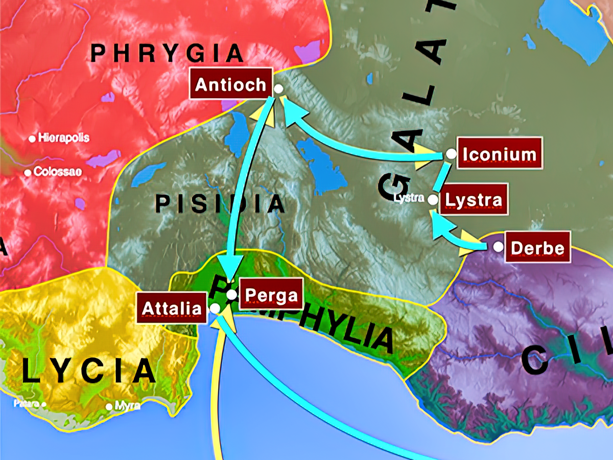
Videos—Paul: 1MJ (Pamphylia-Lycia)
-
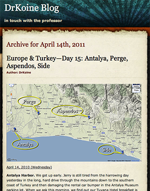
Pamphylia—Perge
- Perge: Blog
-
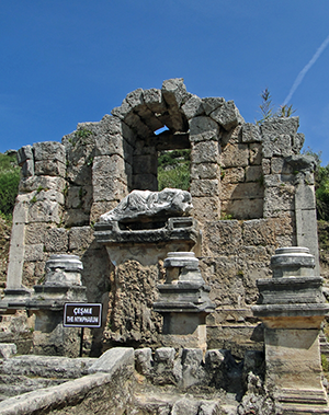
Perge: Nymphaeum
A nymphaeum was a civic water fountain fed by a fresh water spring or river that was an expensive public works project funded by some benefactor of the city. The structure displayed artistic beauty and supplied fresh water for the use of citizens. The nymphaeum at Perge was unusual, as this fountain was the source of a large water channel that cascaded down the middle of the main colonnaded street, collecting in pools at regular intervals for almost a mile. These pools were stocked with fresh fish. Roman roads were so well travelled that the wagon wheels made ruts visible even today.
-
Perge: Theater
The theater at Perge is not accessible to tourists. Some intrepid visitors with inquiring minds, however, and determination to plow through chest-high thorn bushes can gain a view of this grand ruin left today to the elements.
-
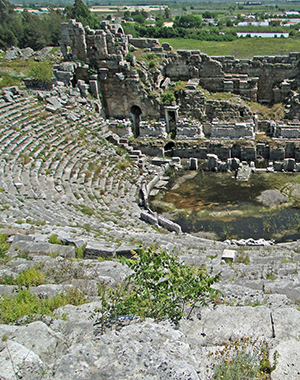
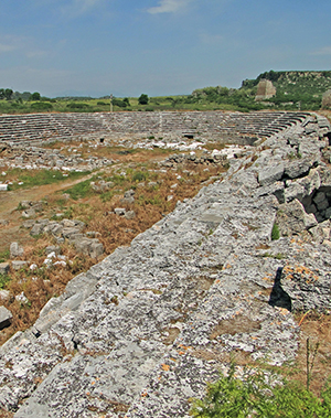
Perge: Stadium
The second-century AD stadium at Perge with a capacity of 12,000 is second only to the stadium of Aphrodisias in size, and almost as well preserved. The stadium used a barrel-vaulted construction technique. The monumental entrance on the south end no longer survives. On the east side, the barrel vaults provided 20 rooms to house shops, whose shopkeeper’s name or trade is indicated in wall inscriptions.
-
Perge: Roman Baths
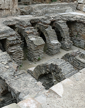
Perge developed a number of monumental baths. The northwest cardo sported a bath dedicated to Nero in the middle, and at the end, a monumental bath graced with a monumental nyphaeum. The southeast cardo also had a bath near the ancient Hellenistic Gate, the main entrance into the city. This bath is well preserved and illustrates the multiple rooms of decreasing temperatures of steam heat (cauldarium, tepidarium, frigidarium), as well as the intricate underground operations that channeled the steam.
-
Perge: City Inscriptions
Perge reveals a number of important inscriptions. Those along the street north of the agora market are the most interesting in terms of honor and status claims for the ancient city itself. One inscription actually personifies Perge, while another can be read by a group out loud antiphonally to emphasize its dramatic impact.
-
Perge: Northwest Gate
The main street of Perge intersects with another street heading northwest near the monumental nymphaeum supplying water for the street’s cascading canal. As one turns left to head down this intersecting street, one passes the baths of Nero. At the end of the street one is greeted by another monumental nymphaeum that supplies even more Roman baths. Across from this nymphaeum is the northwest gate heading out of town toward the Pisidian highlands. Through this gate Paul and Barnabas would have traveled to make their way to Pisidian Antioch on the 1MJ.
-
Perge: Via Sebaste Road
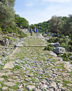
Paul and Barnabas leave Perge on the 1MJ heading inland for the highlands of Pisidian Antioch. Coming out of the northwest gate, they have two options. One option is the central road straight up into the highlands. This route is shorter, but also much more difficult due to the steep climbs and uphill journey all the way. The other road is the main Roman road, the Via Sebaste more to the west. This route is longer, but a much easier ascent into the mountains. Portions of the Via Sebaste are still in tack to this day, including the first pass out of the Pamphylian plain into the Taurus Mountains with several inscriptions along the road and the first traveler's rest stop and spring water well.
-
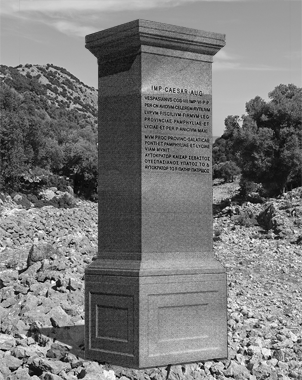
Perge: Via Sebaste Inscription
One of two roads Paul and Barnabas may have taken out of Perge on the way to Pisidian Antioch is the Via Sebaste. A portion of this ancient road is still preserved in the first pass out of the Pamphylian plain into the Taurus Mountains. Inscriptions are viewable that document society, Roman milestones, and repair of the Via Sebaste by emperor Vespasian. The Vespasian inscription also provides the earliest datable evidence that Lycia and Pamphylia actually were a double province at this time as a result of early reform measures instituted by Vespasian.
-
Perge: Patroness Plancia Magna
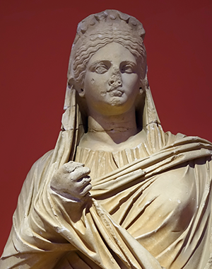
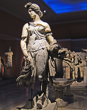
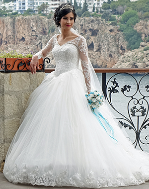
Plancia Magna was a wealthy patroness and native of Perge. She had royal blood, high family status, and great power and influence in Asia. Her father was the Roman senator and proconsul Marcus Plancius Varus, and her mother the Herodian princess Julia. Her brother also was a Roman senator. Her maternal grandfather was King Tigranes of Armenia, and earlier maternal ancestors included King Archelaus of Cappadocia and Herod the Great of Judea with his wife, Mariamne. Her mother was priestess of Artemis in Perge, while Magna herself became high priestess three times over, not only of Artemis, but of the imperial cult and of the mother of the gods. Plancia Magna, her brother, and maternal cousins are the last known descendants of the Herodian dynasty. Inscriptions document that Plancia Magna and her family were extraordinarily civic minded, charitable, and generous, so much so that they gained status as “second founders” of Perge, with the honorific title “Ktistes” (“Founder”). One of her most significant benefactions was beautifying the Hellenistic Gate, restoring the side towers and courtyard with a two-tiered triumphal arch and statuary to Greek gods and goddesses, including the Roman imperial family. The Boule, Demos, and Gerousia of Perge gave her the honorific title “Demiourgos,” the highest public office in government, which meant that she sponsored the local games held in Perge. The picture is a statue of Plancia Magna held in the Antalya Museum.
-
Perge: Neighboring Ariassos
Ariassos is perched dramatically on a steep hillside in the mountains surrounding Perge on the Pamphylian plain. Not mentioned often in ancient sources, Ariassos as part of Pisidia moved from Seleucid to Pergameme to Roman control (when Attalus III left his kingdom to Rome 133 BC). Augustus incorporated Ariassos into the Roman province of Galatia. The best preserved ruin is the triple arch gate that had four statues. The gate used to have important inscriptions illustrating Roman empire rule, but these inscription blocks have been removed. By whom is unknown.
-
Perge: John Mark's Departure
When the boat landed at Perge of Pamphylia on the southern coast of Asia, John Mark left the 1MJ mission team. Luke does not indicate why. Paul, however, interpreted John Mark’s departure as a defection from the mission team and an abandonment of the mission. Paul and Barnabas later would have a serious disagreement over the matter of John Mark that spit the mission team at the beginning of the second missionary journey.
-
Pamphylia—Aspendos
- Aspendos: Blog
-
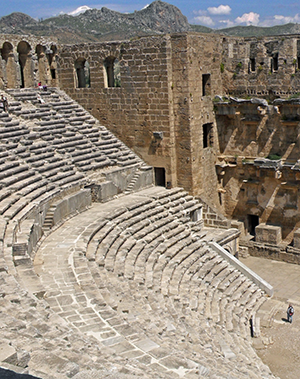
Aspendos: Famous Theater
Aspendos was a close neighbor to Perge about 10 miles inland on the Eurymedon River, a busy port in ancient times, but not a city of great historical import. The city is famous, however, for its theater, perhaps the best-preserved from antiquity, originally seating about 7,000. The theater was designed and built in 155 B.C. by its noted Greek architect and resident, Zenon. The three-story skene or scaenae frons (stage), one of the few still surviving today, enveloped and completely enclosed the audience for unimpeded focus on the activities within its confines. A wooden partial ceiling leaned out over the cavea (seating area), but does not survive. The top tier of the structure reveals 58 post holes that secured beams for extension of the velarium (awning) that could be pulled out over the audience for even more shade when needed.
-
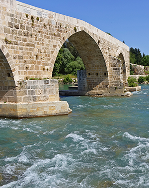
Aspendos: Eurymedon Bridge
When the Romans built a bridge over the fast-flowing Eurymedon River, Roman engineers angled the bridge strategically so that the turned piers slowed the water flowing downriver, and wedged-shaped masonry reinforcements on the central piers impeded the river undermining them. Seljuk Turks replaced the bridge in the 13th century but reused the ancient Roman foundations, as well as other Roman stone blocks. Thus, the rebuilt bridge followed closely the Roman design. The ancient Roman bridge, however, stood higher at its peak.
-
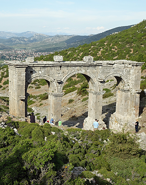
Aspendos: Ingenious Aqueduct
Aspendos has one of the most impressive Roman engineering accomplishments of the empire in its aqueduct system. Headwaters from two sources brought water near to Aspendos by a conventional channel of bridges and tunnels. The remaining mile, however, was the trick, as the water not only had to cross a low, swampy valley, but then also had to climb a steep and high slope up the acropolis to a holding tank. Roman engineers designed a complex combination of elevated, arched bridges to reduce the drop height to the bottom of the siphon (venters) and inverted siphons (following a “u” pattern rather than the tradition “n” pattern) with two unequally high, massive water towers on the north and south ends of the valley in a closed siphon system completely bled of air. These towers, at 131 feet, were almost as high as the famous Pont du Gard aqueduct in France (160 feet).

-
Pamphylia—Side
- Side: Blog
-
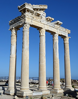
Side: Ancient Site
Side today is a resort area that in ancient times was a port city about twelve miles from Aspendos. After occupation by Alexander the Great, Side became thoroughly Hellenistic in culture. The Roman general Pompey brought the city under Roman control in 67 BC. Commercial prosperity in olive oil and port trade swelled the population to 60,000 in Paul's day. This port also was notable for its slave trade. The agora is square and has the ruins of the round Tyche and Fortuna temple. Some of today’s ruins date back to the second century AD.
-
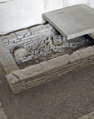
Side: Archeological Museum
The museum at Side is housed in the ancient public baths area. While the museum is small, some of its holdings are most unusual among museums in Turkey. Of the significant displays, the most important is of several unusual inground Roman burials. (Romans normally cremated the bodies of the deceased and preserved the bones within a bone box.) Another significant display is a collection of Roman capalar anchors and other items recovered from the sea in the port area. A third significant display is one of the very few depictions we have of the myth of the punishment of Ixion, whose story illustrates multiple violations of fundamental guest-host social expectations (zenia). One violation was the revenge murder of his father-in-law over an ongoing dispute at a family feast, the first accusation of kin-slaying in Greek mythology. The other violation was of the hospitality of Zeus after Zeus had had pity on Ixion being spurned by all his neighbors and inviting him up to Mount Olympus. Ixion, however, failed to hide his lust for Zeus’s wife, another egregious violation of zenia codes. In his wrath, Zeus ordered Ixion bound to a winged, fiery wheel perpetually spinning across the heavens forever. The relief housed in the Side Museum depicts Ixion affixed to the fiery wheel.
-
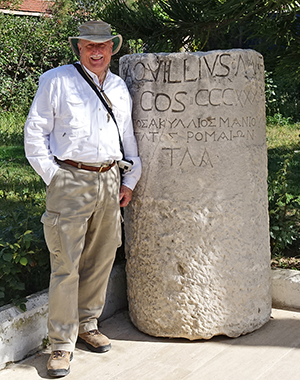
Side: Roman Milestone
During the construction of a resort hotel in the area of Side, a previously unknown bilingual Roman milestone was discovered still standing in situ. The milestone was placed during the proconsulship of Manius Aquillius, first governor of Asia, but incorrectly refers to Aquillius as “consul” rather than “proconsul.” The milestone also incorrectly identifies Aquillius as “governor of the Romans,” which, of course, he was not; he was governor of the Asians. The milestone marks Roman mile 331. The question is, from which origination city?

-
Pamphylia—Attalia
-
Attalia: Blog
Read our journal about our drive down to Antalya, the modern port of ancient Attalia, out of the highlands of Antioch of Pisidia. Late in the afternoon, we visited the famous Antalya Museum. The blog includes pictures and a movie at the end of the blog. Click image to open another browser window to read blog, or click here. We also took in the famous Antalya harbor and Hadrian’s Gate the next morning. For that blog, click here.
-
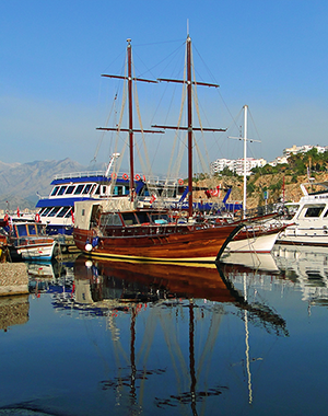
Attalia: Paul 1MJ
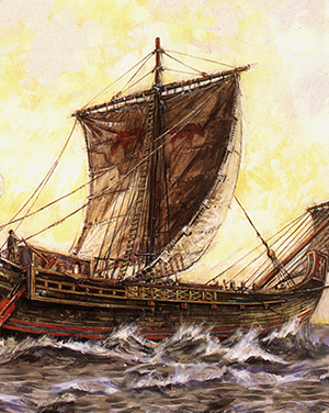
The breakwaters of the modern harbor of Antalya follow the lines of the breakwaters of the Roman port of ancient Attalia. The waters of the harbor are so clear, you can see 30–40 feet down. The port of Attalia was the last stop of Paul and Barnabas on the first missionary journey before sailing home to Antioch of Syria. However, something quite strange happens at Attalia, if one pays close attention to the map of the first missionary journey.
-
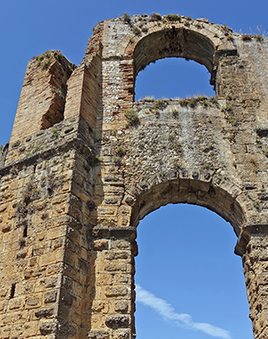
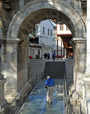
Attalia: Hadrian's Gate
Hadrian’s Gate was built by the citizens of Attalia in honor of the emperor’s visit to their city in A.D. 130. This gate is the only surviving remains of ancient Attalia. The form is the standard triple arch, and had two stories, although the second story has been lost to time. The upper story probably housed statues of the emperor and his family. The gate had two towers on either side made of plain stone blocks, but one tower shows remodeling during the Seljuk period. A Plexiglas ramp is built over the stones of the original road that ran through the gate and allows one to peer down and see the road beneath.
-
Attalia: Antalya Archeological Museum
The prize-winning Antalya Museum, one of the largest in Turkey, is gorgeous. The museum houses outstanding works of art and other items, but displays only about 5,000 of its 30,000 artifacts. The imperial statues, sarcophagi, and coins stand out among these holdings. Our favorite, however, hands down, is the marble masterpiece, “The Dancer,” which came from excavations at Perge. The delicate lines and consummate display of energetic movement in this work of art are beyond words in person.
-
Attalia: Inscription Workshop
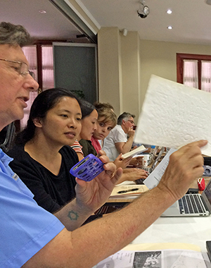
Dr. Mark Wilson of the Asia Minor Research Center facilitated an epigraphy seminar in Antalya led by Professor Rosalinde Kearsley of Macquarie University in Sydney, Australia. Dr. Wilson led the group in a walking tour of old Antalya focused on some of the ancient inscriptions to be seen in the old city, particularly the Julia Sancta patroness inscription at Hadrian’s Gate. Interesting sights and history. The picture shows Dr. Wilson explaining a “squeeze,” an impression made of an inscription by squeezing damp paper material into the letter cavities in the stone for drying and later study.
-
Attalia: Antalya Modern Life
The Antalya harbor continues to grow and develop its tourist tradition. The port is busy with tour boats ferrying passengers around the harbor for a view from the water. The high cliffs at water’s edge provide a breathtaking view of the beautiful seacoast framed by the Taurus Mountains off in the distance that surround the fertile Pamphylian plain irrigated for citrus crops and other produce. The spectacular ocean vistas make perfect backdrops for a parade of wedding parties doing bridal photo shoots in public.
-
Attalia: Harbor Boat Ride
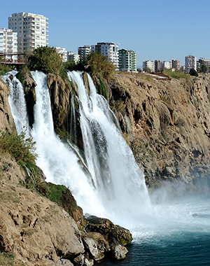
Antalya harbor tourist services offer mini-cruises around the harbor area and down the Pamphylian coastline. The steep cliffs offer staggering views of the coastline from above but amazing discoveries of caves and tunnels from below on the water. The most dramatic scene is coming around a cliff edge to be confronted by the roar of the fresh-water Lower Düden Falls crashing directly into the Mediterranean sea.
-
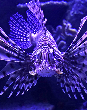
Attalia: Antalya Aquarium
Antalya Aquarium boasts the world's biggest tunnel aquarium, and they are correct. The tunnel is a huge “U” shaped walkway that goes forever. The aquarium is wonderful, and worth the effort to get there. I learned of Demre Çay Agzi Channel eels that migrate all the way to our Gulf of Mexico after birth, but return to Demre Çay Agzi Channel to spawn, and during breeding migrations can switch between salt and fresh water. Fascinating! And I did not think we had any direct connection to Turkey!
-
Attalia: Blog
-
Lycia—Phaselis
-
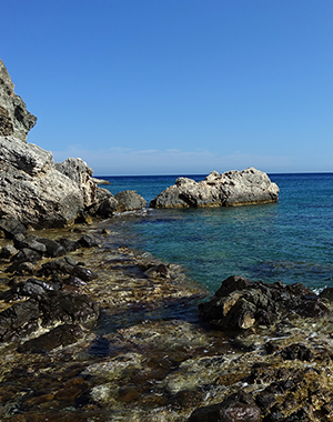
Lycia—Phaselis: Three Harbors
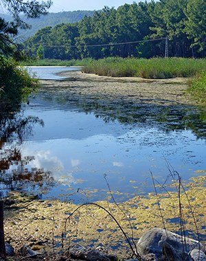
We encounter the Pamphylia and Lycia regions on Paul’s first missionary journey. Luke mentions the seaports of Perge on the way inland and Attalia (Antalya) on the return to Antioch. The Pamphylian-Lycian region had numerous other significant cities, especially on the coast, such as the ports of Side and Phaselis. Originally established by the Rhodians in the 700s BC, Phaselis was an important Lycian port supporting the commerce of Greece, Asia, Egypt, and Phoenicia. Framed by the Bey Mountains, this port rich in Greek and Roman history notably had three useable harbors still viewable today. One of the significant long-term problems for this city was being surrounded by swampy regions that plagued her citizenry with malaria and other diseases.
-
Lycia—Phaselis: Archeology
Ancient Phaselis was a port of Lycia just south of Attalia (Antalya) of Pamphylia. Remains of the aqueduct greet visitors in the parking area, which is next to the swamps that surround the site with the seashore right on the other side of the road. One walks up the ancient cardo (main street) past inscriptions documenting the Roman history of the site. The main road ends with Hadrian’s “Waterway Gate” leading into the south harbor area. The baths of Domitian along the cardo still show the dedicatory inscription over the main entrance. Other baths near the agora show the ancient system of steam-heating and also are near the theater with its spectacular view of the Bey Mountain range close by. Visitors easily access the harbor beaches. A long, steep climb up the cliffs near the south harbor beach reveals a breathtaking overview of the entrance to the harbor.
-
Lycia—Phaselis: Three Harbors
Videos-1MJ > Cilicia Syria Cyprus Pamphylia SouthGalatia
Videos > Videos-1MJ Videos-2MJ Videos-3MJ Videos-4JR Videos-Rev