Archive for the ‘ Photography ’ Category

April 11, 2010 (Sunday)

Karaman Museum. After breakfast at our little Karaman Hotel, we head out to find the Karaman Museum. We spend about 1 ½ hours there. The museum was very easy to find from our hotel. You almost cannot recognize the museum, though, because the building is disguised by a mosque right next door. No entrance fee and very hospitable—they served us hot Turkish tea while we visited the museum. One notable item of the museum is a fourth-century inscription mentioning a Michael who is bishop of Derbe, not only a rare mention of the city of Derbe in inscriptions but also a Christian connection running three-hundred years all the way back to the apostle Paul.

We finished up the museum and left Karaman about 10:37 am. We head out on our way to Konya, which is the modern city of ancient Iconium, another city along Paul’s first missionary journey.

Konya (Iconium). We traveled on D715 to Konya, and the weather today is rainy and cold! This cold and wet day is our first inclement weather in Turkey. Found our hotel in Konya kind of by accident. We were trying to locate it, and Jerry followed his nose, and suddenly there was the hotel right in front of us. You just can’t beat that radar of his. We really like the hotel. The style is definitely Turkish and very nice. Our hotel is right across the street from the Melvana Museum, actually an old mosque converted into a Muslim museum, and constant tour busses are coming and going from there. The museum celebrates the life of a very famous Muslim philosopher who is highly revered in the entire Muslim world. The Melvana Museum is the main attraction in town. Konya is very Muslim, conservative, and religious. Women do not go out in public without veils.

I checked in while Jerry parked the car in the underground parking lot a half block away. We go up to the room to get into warmer clothes, rain ponchos, and umbrellas. We ask for a lunch recommendations at the front desk. We could not find the restaurant recommended, however, so we go to a nice restaurant right next door to the hotel. Good is very good. While we were sitting there, suddenly a large group of men all with skull caps on are coming around the corner carrying what looks like a casket (bright green color) and cross the street. We’re not quite sure whether it’s a funeral or some symbolic event but it seems they are headed for a cemetery, which appears to be behind a stone wall across the street.

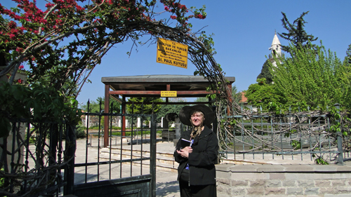
Konya Archeology Museum. After a good lunch, we inquire about the Konya Museum, our reason for staying in Konya, and our hotel manager tells us it’s “straight down the street” about 400 meters. We strike out on foot walking to the Konya Museum. We try and try to use the Garmin in its pedestrian directions mode, but nothing the Garmin is saying makes since, because this town has NO “straight” streets. After going what Jerry is sure is more than 400 meters, we determine we are wasting time and go back to the hotel to ask for more directions. The manager instructs the bellboy in Turkish to do something, and the bellboy walks us outside the hotel and down to a bus stop. He apparently tells the driver that we need to get off at the Archeology Museum. That museum bus stop indeed is all the way down on the same street, as the manager had said, so I guess the building is “straight down the street,” but sure as heck a lot more than 400 meters! So, we finally arrive.

Entry fee is 3TL. We are the only people there, and the ticket attendant has to unlock the doors for us. The courtyard is full of stone carvings, gravestones, and inscriptions. You can tell that the landscaping is nice, and had spring arrived, the flowers would have been pretty. We had only cold, wet rain.

Just inside the doors of the museum building is a stunning collection of Roman sarcophagi—truly amazing. These stone monuments are some of the best we will see, except for those in the museum of Antalya.

The museum has very interesting holdings, including the skeleton of a baby in its burial position from the Neolithic age (6500-5500 BC). The baby was about a year old at death. Jerry also enjoys a collection of seals, because they illustrate how the cylinders were rolled to create the impressions with greyscale images of the imprint of each seal.

We finish the inside and have yet to find the Derbe, Lystra, and Iconium inscriptions that Jerry thinks should be in this museum. Jerry’s spirit is sinking in disappointment—but we turn right coming out of the entrance, and there are the inscriptions under a little tin roof next to an outside wall. Hurrah! They are found. Jerry’s delighted and goes about taking pictures. Suddenly, however, he is seized with a bad muscle spasm in his back and has to sit down for a while. The spasm is very painful. Jerry thinks he was holding his back for a long period at a bad angle trying to take the inscription photographs, and after a while his back just said enough is enough. Finally the pain subsides, and he continues with the picture taking.

We finish up at the museum at about 4:30 pm and decide to walk back to the hotel rather than wait for a bus, even though cold and damp. Finally back in our room, we get warmed up and order room service (about the same price as going out) since outside is so wet and cold. Food is good. Jerry has meatballs, and I had a chicken skewer. Fresh fruit for dessert and Coke to drink! What could be better? Jerry, as always, goes about setting up his charging station for all his electronic equipment.

We look at plans for tomorrow and try to determine how we will find the tel of Lystra, which may prove to be even more of a challenge than Derbe, but we’re going to give the search our best shot.

For a video of the Karaman and Konya action today:

April 10, 2010 (Saturday)

Adana. Up early and get packed. We go to business center to print maps to Derbe and Lystra. Google map won’t print satellite view so Jerry gets his camera and takes pictures of the computer screen. Hopefully, we’ll be able to find the sites if we are on visual reconnaissance only. Hit the petro station by the Hilton. Wow! 90 Turkish lira for our diesel fill up, and we only needed ½ a tank.

Tarsus. We left the gas station by the Hilton at 8:20 am. We stopped briefly for me to buy some snacks in the market for breakfast: cookies, orange juice, etc. The view of the Taurus Mountains from the highway is very pretty, so we stop by the side of the road and take some pics and a movie of the mountains. This is the route that Barnabas traveled to retrieve Paul from Tarsus to go back to Antioch to help with the Gentile work there. Back in the car and on to Tarsus.

St. Paul’s Well. The Garmin works, and we find St. Paul’s well by using the “point of interest” feature on the Garmin. It leads us to the place, but some roads are blocked for some official event. Turkish military are in dress clothes and lots of dignitaries lined up. So, we go around a couple of times and find our way to the other side of the event. We park on the street and walk through the grounds of a mosque to get to “St. Paul’s well.” The fee is 3 Turkish lira. The well itself is not of particular interest, with the association with Paul only tradition, but the excavations around the well revealed Roman paving stones believed to date somewhere in the first three centuries A.D., so that is interesting.


The site is nicely kept and manicured, with pretty gardens and roses just budding out. The roses will be very beautiful in a few weeks. Jean enjoys a stroll through the tidy landscaping.

Tarsus Roman Road. From there we go back to the car to review Mitchell Reddish’s description in his sites of Greece and Turkey book of how to get to the Roman road excavation in Tarsus, which is located about 500 feet southwest of St. Paul’s well. Jerry measures out some steps to get distance and visual bearings on the points of the compass, and we start out. We walk around the traffic round-about to get around the official ceremony and presentations that are going on in the main market square, and decide to ask one of the officials standing nearby for directions. We get enough information to go in the right direction and find the Roman road! Yeah!! Jerry is very excited! We look through the fence and then walk around the area to find the ticket window, but the site is closed today! Ah! Turkey—one just never knows for sure what is or is not open at any time. So, we can’t get in to visit the actual site close up, but we have a good view from the side, and Jerry gets good pictures anyway; he just didn’t get to walk on the road, which my scholar so wanted to do.

We started to head back to the car but decided to take some pictures so we can give visual “location” information to others who may need to know who are trying to find the Roman road. By now, the presentation has broken up, and the dignitaries are leaving, all having red roses in their hands. One of them handed me his red rose as a gift. So nice. We get back to our car and drive a few blocks to a fruit stand. I buy us 2 bananas, 2 apples and 2 oranges.

Roman Yolu. Now we’re off to find another Roman Yolu (road) 10 miles north of Tarsus. Jerry still wants to walk an ancient Roman road, just one of his personal goals for the trip. This site was mentioned by Reddish in his book. We had to go way around to get to the correct road, because E90 has no egress. We finally get to D750 North and head out. Sure enough, we find the “Roman Yolu” sign on the side of the road pointing left up a narrow winding road up the mountainside to Saliliki village. Our quest is looking promising. We ascend this winding road up the mountainside that continues to narrow to almost one lane and through Saliliki village with children in the street, cows being herded, etc. We got lots of attention, because I imagine they don’t see many cars or Americans in these parts. We drive, drive, drive, all the while looking all around to see if we can find another “Roman Yolu” sign directing us to the site or the Roman road itself.

Our forward progress comes to a dead stop in a dirt driveway at someone’s house. The road just completely dead-ends in a driveway! We start to turn around. A young man comes out to the car, and we try to ask if he knows where the “Roman Yolu” is. He speaks no English whatsoever, but he tries to help. He gets in the back seat to “show us the way” (hand motion communications). He’s very nice. He gives his name, Mehmet. When we get to the fork in the road, he motions for us to stop, and he points to the left fork, which is back the way we came, and gets out of the car. We offer to pay him, but he won’t take anything. The Turkish really are so nice. We determine that all he understood from what we were trying to ask is the “yolu” part, which means “road,” and didn’t recognize the word “Roman.” He thought we were asking how to get back down the mountainside to the paved road from which we had turned. So, we end up back at the Roman Yolu sign by the highway where we had started. Talk about a Bill Murray, “Groundhog Day” experience!

We decided to take one more stab at finding the road up the mountainside, figuring we just had missed another sign or something, and start back. We mark the mileage so we’ll know exactly when we get to the 5 km distance that the “Roman Yolu” sign on the main road indicated. We get to the 5 km mark and stop. Nothing. No signs. No ancient Roman road, Jerry is exasperated to be “so close, yet so far.” He even gets out and hikes a long way both right and left of the road, figuring overgrowth or a rise in the ground hides the road, but still finds nothing. He sees beautiful scenery, but no road. We have another Colossae experience on our hands here. [We searched literally for hours outside of the town of Denizli on the sabbatical of 2001–2002 trying to find the tel of Colossae, but never did find the tel.—Jerry] Jerry is real disappointed. Once again on this trip, he misses out on walking down a Roman road Paul may have walked.

Cilician Gates. We go down one more road and decide we must give up, so we go back to the highway, set the Garmin for our final destination of Karaman, and off we go to find the Cilician Gates on our way. We do find the big pass (not really a gate, just a pass through the Taurus Mountains) and take some pictures. Paul would travel through this mountain pass on his second and third missionary journeys. Jerry, of course, is delighted to get a movie of our car going through the pass. Then on we go, pushing to find the unexcavated tel of Derbe.

Derbe. Our nice, fast four-lane Highway E90 plays out, and we are back to D750, which soon becomes a two lane and is very tough driving. I have never seen so many trucks of all kinds. The Garmin leads us towards Karaman, and when we get about 20 miles away, we start looking for the road to Derbe by way of Sudugari village. What do you now, but suddenly to our wondering eyes did appear a sign pointing the way to Sudugari, so we turn and go through Sudugari to Ekinozu and on through that little village. Even in such a little village, we feel quite fortunate to find yet another sign to Derbe, so we turn and follow our noses, and voila! There it is—a large oval shaped tel with a rather beaten up sign that appears marking the site as Derbe.

Jerry is ecstatic to find the last stop on Paul’s first missionary journey before they turn around to retrace their way back thorough areas they had preached in South Galatia. Traveling these distances (in a car) gives a new realization of how determined and dedicated Paul was to spreading the Good News! We stay at Derbe 1 ½ hours and walk all around the top, etc. making movies and pictures. Little gophers are everywhere popping up out of their holes and running around. We try to get some pictures of them, but they are fast little critters. As we are going back to the car, Jerry noticed broken pottery pieces that are ancient by their markings, he thinks Chalcolithic. We assume erosion and rain wash has unearthed them. Oh, what treasures there must be under all this dirt!

Karaman. We drive the short distance on into the modern city of Karaman near the tel of Derbe. After traveling these dusty, dirty roads, the car is filthy. We stopped at a Shell station for fuel, and it’s 95 Turkish lira. No wonder everyone walks everywhere over here. The attendant speaks some English, so we ask directions to our hotel, and he gives directions that square up with what the Garmin is telling us. We also asked about a car wash, and what do you know—they have one, and it’s free with a fill up, so we get the car cleaned up. Only one wrong turn on the way to the hotel, and we find it. We check in and are served hot tea while we wait. They want to keep our passports, but we talk them into copying them and giving the passports back to us. Up to our room, which is large, with a nice sitting room (thank you, Levent). The restaurant is on the sixth floor, so we go up and have dinner. Dinner is decent Turkish fare. I think we’ll rest tonight. Our itinerary tomorrow is catching two museums and some short driving. Shouldn’t be a hard day. We’ll head to Karaman Museum tomorrow morning after breakfast.

For a video of the Tarsus and Derbe action today:

April 9, 2010 (Friday)

Tarsus. Up at 6:00 am and downstairs for breakfast at the Hilton Adana where we finally crashed after yesterday’s hard travel with so many miscues. Very large, good breakfast buffet. Now, we’re off to Tarsus. We get directions from the desk to get to the main highway D400 out of Adana, and off we go north to Tarsus, birthplace of the apostle Paul, to find the Tarsus Museum. Getting to the highway is pretty easy, and, lo and behold, the Garmin is working! Maybe things are looking up. But when we get to Tarsus, the Garmin becomes useless again. So frustrating . . . the streets are unmarked, small, and confusing, but we finally find our sabbatical target: the Tarsus archeological museum, rarely visited by any tour groups to Turkey.


Tarsus Museum. The museum is small, no admission fee, and the hours are Monday–Friday 8:30–12:00 and 1:00–5:00 pm. Holdings are few, but some are first century AD, including some pottery, vases, jewelry, statuary, and coins. The coins are not marked well, and the cabinets are dark. The museum clearly has little budget. We have an almost comical routine with the museum’s motion lights. Since the exhibits are lighted by motion lights, we have to keep moving around in constant motion like the sharks in the Gulf of Mexico tank at the Aquarium of the Americas so the lights will stay on for Jerry to take pics. After we finish, the young lady at the desk has observed our keen interest in their little museum and is very nice and gives us lots of brochures about various places in Turkey and a poster of the 1000-year anniversary the celebration of Paul.

Antakya. We plan to come back though Tarsus to do more touring, but we staged ourselves in Adana to be within striking distance of a day trip down to ancient Antioch of Syria (today part of Turkey, but the modern Syrian border is only 12 miles away). OK, the Garmin is as worthless as a brick, interminably unable to get a satellite fix, and the streets are unmarked, so now how do we get back to the highway so we can get on our way for the long push down to Antioch? After many wrong turns, we finally see a sign back to Adana and find our main D400 highway. Out on the main highway, the Garmin finally awakens out of its comatose state, gets its bearings, and becomes functional again. The Garmin provides us directions down to Antakya, the modern name for ancient Antioch of Syria.

After about a 2 ½ hour drive, we get to Antakya about 12:30 pm and have similar issues with finding our sabbatical target: the archeological museum. The Garmin is useless in the city, not because the unit does not have a satellite fix, but because Turkey has yet to discover labeling their street names with signs big enough actually to read sitting in a car. So, round and round we go. Very frustrating. We have the sinking feeling we have traveled for hours only to have wasted our time having reached our destination but completely clueless where we are or how to get to a specific location in this bustling, crowded, very Muslim and very foreign city. We finally see a policeman, stop, and ask directions. The English exchange is quite labored, but we find out we think we are close. We finally see the museum down the way, but now, where do we put this car? No on street parking, and no parking lots are apparent. We go round and round looking for a solution, but being careful not to stray too far from the museum to get lost on these twisting, turning streets up and down hills. Finally we do find a car park (a little gravel area behind a rock wall—that’s city parking in Antakya!).

Hatay Archeological Museum. The museum is wonderful. Filled with mosaics, one of world’s best and most extensive collection, and a major surprise, a beautiful sarcophagus with the contents still in tact (very, very rare; almost always they are disturbed over the centuries, or robbed). The bones and jewelry found inside are on display. The occupants were an adult male and female and a young female of Alpine nationality. We spent two hours in the museum (2:04 pm to 4:07 pm). Took a few pictures outside of the museum entrance and the city round-about traffic circle in front to give others trying to find the place visual “location” information.

We spent a little time trying to decide if we should try do anything else in Antioch before hitting the road again for the long ride back to Adana. The day is late, and very few ancient remains are left from first-century Antioch, one of the earliest ancient centers of the Christian movement. We have a sense of such stark contrast between then and now, a completely Muslim city with minarets rising on every other corner. Having no good guides, maps, or schematics to how to get to anything of interest left, we felt we just would be wasting our time and decide to head back to Adana.

Adana. We are able to navigate back out to the main highway out of Antakya. The Garmin is working and leading us home to the Adana Hilton hotel. We did have one heart-stopping moment on the drive back. Tooling down the highway on cruise control at highway speeds, an 18 wheeler in front of us blew a tire! Jerry reacted with the reflexes of a cat, safely steering us away and around all the flying rubber at high speed! Whew! What a feat of driving skill. After several hours, we are back at the Adana Hilton and have a wonderful dinner in the hotel restaurant. I had salmon, and Jerry had mixed grill. So delicious!

Back in our room, we review tomorrow’s schedule and try to figure out how we will find our hardest target of the day, the ancient tel (mound) of Derbe, the termination point of Paul’s first missionary journey. We decide we’ll try the GPS in the morning to see if she gets a satellite fix. As a backup plan, before we leave the hotel, we will go to the hotel’s business center and print additional Google map information. (Jerry already had located what he was pretty sure was the tel through research before the trip and studying Google maps.) In addition, we will go to Tarsus again, but this time to take in a few sights around town. We then plan to make our way through the Cilician Gates, the ancient pass through the Taurus Mountains, and on to Derbe. We then will finish the day’s adventure on to our hotel in Karaman, the modern city near the tel of Derbe. We have quite the ambitious itinerary for tomorrow! I hope we can make our destination. Finally, to bed.

For a video of the Tarsus and Antakya action today: